Sand Lake Archaeological District
The Sand Lake project near La Crosse was one of the most significant research efforts in MVAC's history. This multiyear project provided an unprecedented look at the sophisticated agricultural practices of Indigenous occupants of the area over five hundred years ago. Surface surveys conducted by UWL staff and students and local volunteers found a concentration of Oneota sites around the mouth of Sand Lake Coulee, a small tributary valley northeast of Onalaska. Excavations in 1982, 1984, and 1986, supported in part by funding from the National Science Foundation and Earthwatch, found perfectly preserved ridged fields buried under later sediments. The discoveries earned national attention and even appeared on the cover of American Antiquity, the journal of the Society for American Archaeology. Besides the importance of the finds themselves, the project's Earthwatch connection took public participation--and awareness of these fragile cultural resources--to the national and international level. In subsequent years, expanding modern development triggered additional excavations in habitation sites surrounding the ridged fields. Today the area is almost entirely developed, with only small areas preserved, but knowledge of how Indigenous peoples shaped and made use of the land remains.
 Group photo
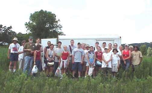
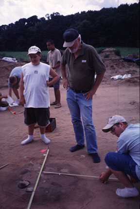
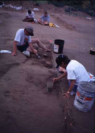
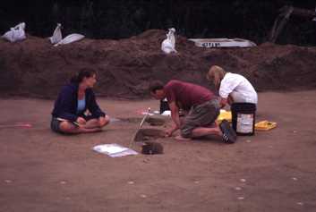
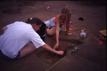
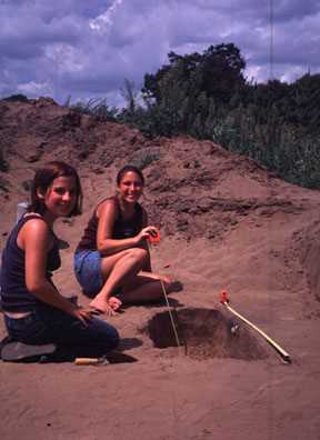
During the summer of 2003 the Mississippi Valley Archaeology Center’s annual Public Field School had the opportunity to excavate some features within an Oneota house structure at the Meier Farm Site (47 Lc 432) in Onalaska, Wisconsin. The Public Field School is held for one week each summer. It provides the public with a wonderful opportunity to work with real archaeologists on authentic research. Twenty-one great individuals ranging in ages from middle school students to adults participated in the 2003 public field school. During the course of the week the participants experienced hot, dry desert-like conditions and a sudden downpour of rain that tested their dedication to archaeology and the project. After the public’s week at the site, MVAC’s college field crew completed the site’s excavation.
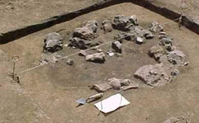
 The site prior to excavation
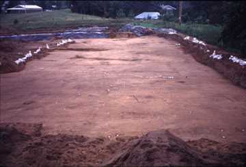
The Meier Farm Site is part of the Sand Lake Archaeological District, and represents a village associated with extensive ridged agricultural fields that have been found nearby. The house structure that was being examined in 2003 was one of the very few such structures in the La Crosse area that archaeologists have ever had the opportunity to investigate. The others that we presume existed have all been destroyed by decades of cultivation. This structure was defined by over 300 post holes, small circular stains left when wooden posts decayed. The structure was probably similar to a wigwam, or a long rectangular building. The walls might have been covered with mats or hides, or might have been mostly open. One of our research goals is to figure out what season(s) the structure had been occupied, and that will give us a better clue as to how the structure might have looked. The deer mandibles found in these features will help us to identify the seasons that the structure was used. Winter facilities will have served very different functions from a summer sleeping or shade area.
Within the structure we found a number of relatively shallow features that suggested mostly cooking activities, as well as perhaps pottery manufacture and stone tool reworking. The hearths were placed in several areas of the structure, not concentrated in one spot, suggesting multiple work areas, either for different activities, or for different groups of people. The number of interior post molds suggests that there might have been racks or other smaller facilities inside. Perhaps there were drying or smoking facilities to prepare foods and hides for storage. All of the activities appear to have taken place over a relatively short period of time, rather than reflecting intensive use over a full year or multiple years.
What we did NOT find is equally as interesting. We did not find large and deep storage pits such as we typically find on Oneota villages. These kinds of pits might not have been built within structures, but might have been placed outside the structure.
Most of the cultural remains that were found at the site are characteristic of the Oneota time period, from 1300 to 1625 A.D. Examples of Oneota cultural remains found at the site included: shell-tempered pottery, end scrapers, fire cracked rock (FCR), burning pits, and basin or bell-shaped storage pits. In addition, we found several features that had Woodland or grit-tempered pottery probably dating to between 700 and 1200 A.D., suggesting that this place had been occupied multiple times in the past.
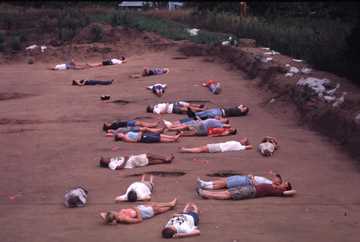 Field School Participants laying within the post molds
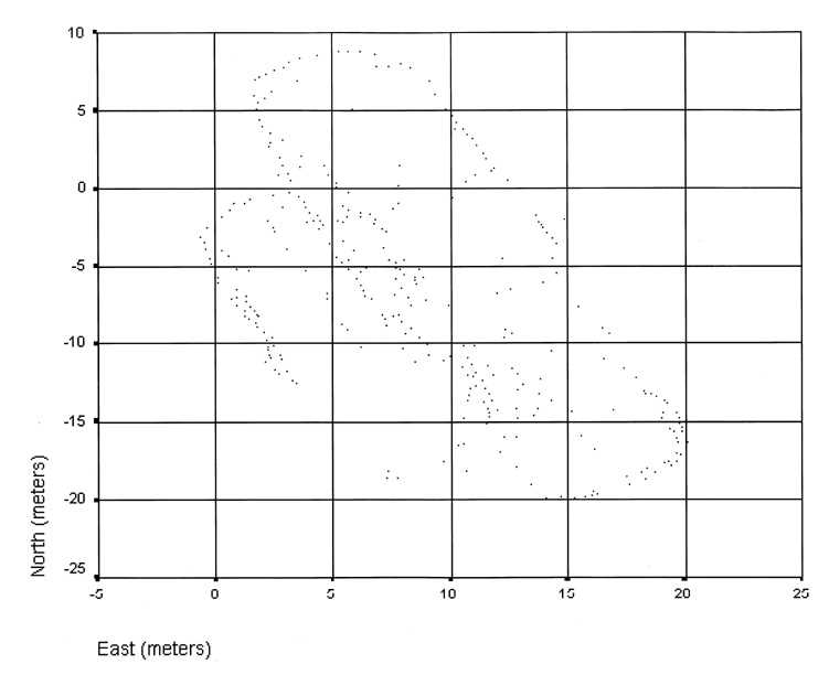 Map of post molds
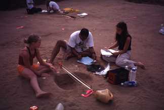
The Meier Farm Site was a salvage excavation project. Recovery of information from the site was needed due to plans to turn the area into a new housing subdivision in the very near future. The Public Field School allowed us to do much more work here than would have otherwise been possible. It gave us a unique view of what life might have been like at 1500 A.D. The 26 field school participants and supervisors working in the structure might have been typical of the total number of people in an extended family that once occupied this structure. Working together as a unit, the crew helped to preserve some of that ancient history for the future.
Individual Feature Descriptions
Here’s what happened with each of the features. Those who joined us in the excavations can see what was found after they left the site, and can see what others were doing.
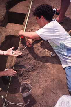
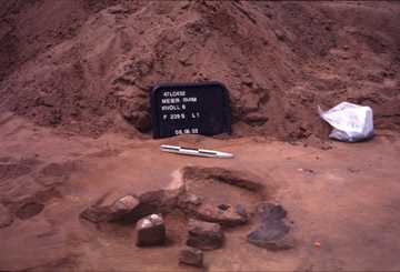
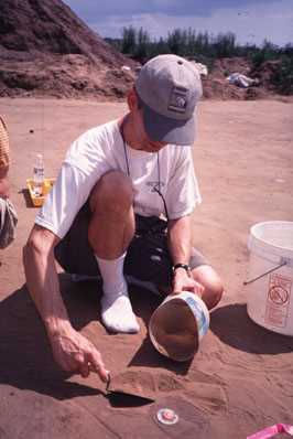
The house structure was identified by the post molds surrounding a series of features such as hearths and pits. Post molds are the organic stains that remain after the wooden support structures have decayed. There were about 320 post molds forming the house. Each post mold was given a number and each feature was numbered 239 A-S. Each feature was given the same 239 number because they are all part of the same structure. The letter after the 239 identifies each feature individually.
Feature 239 A
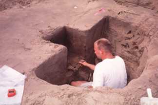
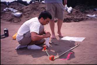
 Mapping a feature
Feature 239 A was excavated by Stephanie, LeVerne, and Jeff. This was a very rich feature that was centered within the house. At first it was thought to have been a sweat lodge since it was surrounded by post molds. Large pieces of FCR were found in the north half of the excavated feature along with numerous flakes, and red ocher. MVAC’s college crew excavated the south half of this feature. They noticed that the feature ended but a post mold in the middle of the feature continued down another 20 cmbss (centimeters below scraped surface). Since the feature and post mold stain are about the same color it was hard to tell whether the feature had a post mold within it until hitting sterile soil and then looking at the profile wall. This post mold within the feature was a common theme for about 3 or 4 of the other features within the house complex.
Feature 239 B
 Excavating Feature 239 B
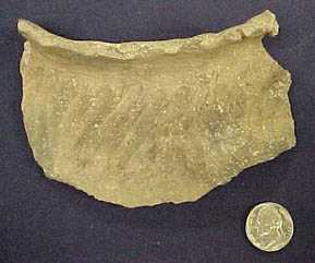
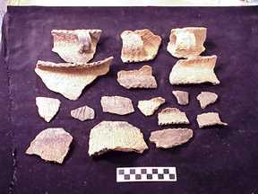 Pottery recovered from Feature 239 B
John, Gregg, and Bob, who are part of MVAC’s college crew, excavated feature 239 B. The feature is located just east of Feature 239A and west of Feature 239 D1 and D2. This feature appeared to be two separated features on the surface. The features were excavated separately according to zones in the soil. Feature B1 rapidly disappeared and Feature 239 B continued. In the first level of 239B and B1 two flakes and one beaver mandible were found. Zone A of Feature 239 B was their largest zone and yielded an elk scapula and a large piece of an Oneota pot. During excavation a sterile area was encountered containing numerous pottery sherds and three rims and three handles which appeared to be from three different pots. This feature was a very large and deep pit requiring a lot of time and patience to excavate.
Feature 239 C
Ryan and his parents excavated Feature 239 C, a basin-shaped pit with a dark sandy soil. The north half was excavated first, followed by the south half. This feature only went down about 15cmbss. Within this feature, however, the excavators found charcoal and small pottery sherds. Feature 239 C lies close to features 239 A and 239 D so they are probably related because of the artifacts found in all three features. This area of the house might have been where a lot of the fire burning and cooking took place.
Feature 239 D
 Excavating Feature 239 D
John, Michelle, Barry, Mary, and Marsha excavated feature 239 D. This was a large feature. On the surface it had a large portion of charcoal in rows so it appears to be the remains of burned logs. Eventually the feature was sub-divided into 239 D1 and 239 D2 because as the feature went down deeper it turned into two distinct features. Feature 239 D1, with the large pieces of charcoal, was carefully excavated around the charcoal. Underneath the charcoal area, the feature stain lightened and the remains of turtle shell were found in very poor condition. Large pieces of FCR were present at the base of the feature floor. Within the boundaries of feature 239 D2, high quantities of Prairie du Chien chert flakes and shatter were found along with some bone and pottery. The artifacts were concentrated in the center of the feature. MVAC’s college field crew finished excavating the first halves of these two features. Artifacts were found that were similar to those recovered by the public crew – pottery, animal bone, and flakes. However, due to time constraints the second halves of these two features were not excavated.
Feature 239 H
Beth and Lauren excavated Feature 239 H that was a shallow pit only going 10 cmbss. The only artifacts that they found were bird bones. The top portion of this feature may have been scraped off by the bulldozer or simply used for a short period of time to process the bird for a meal, which would explain why the pit was so shallow.
Feature 239 J
 Excavating Feature 239 J
 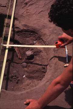 Excavating Feature 239 J
Kameron and Cindy excavated feature 239 J. This feature was rich with artifacts. On the surface however it looked like it may have joined feature 239 K. However during excavation it was discovered that the features were actually two distinct features. The majority of the artifacts found within Feature 239 J were small flakes, charcoal, shell, a deer mandible, a large pottery cluster, and FCR. This features looks like it may have been a burning or cooking pit. There were also numerous small mammal bones found here along with fish scales. This feature was almost completed by the end of the public field school. MVAC’s college crew completed the excavation and found minimal artifacts that included a few flakes and some small pottery sherds. The feature stain was very dark which indicates that a lot of organic materials decayed in this feature pit.
Feature 239 K
 Excavating Feature 239 K
 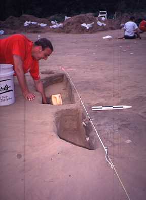 Eacavating Feature
Scott excavated feature 239 K. This feature was about 10 cm west of feature 239 J. This feature had minimal artifacts but had the same post mold within the feature as feature 239 A had. This post mold within 239 K was a very large one. It may have been one of the center posts that helped to hold the structure up. Artifacts recovered included a large piece of FCR, a large flake on the surface of the feature, and bone. Only a matrix sample was taken from the second half when MVAC’s college crew completed this feature. This approach was used due to time constraints and the lack of artifacts found within the first half of the feature.
Feature 239 M
 Excavating Feature 239 M
Jenny and Ashley excavated feature 239 M. This feature was just on the edge of the house on the southwest end of the site. The south half of their feature went down about 20cmbss. And contained large pieces of fire cracked rock; a few pieces of shell-tempered pottery, and red ocher. Within this feature there were two distinct areas, A and B. Area A contained the artifact cluster and Area B was the lighter stained soil around the artifact cluster. Red ocher was one of many types of artifacts to be found in this feature. Red ocher was used for many things such as staining bones and body paint. In the second half of the feature Ashley uncovered not one but two deer mandibles. Deer mandibles are useful artifacts to recover at a site. The age of the mandible may indicate what time of the year the occupants were at the site as well as what they were eating. The feature didn’t continue down much farther and no additional artifacts were recovered after the removal of the deer mandible and numerous pieces of FCR. MVAC’s college crew finished the second half of this feature.
Feature 239 N
 Excavating Feature 239 N
 Excavating Feature 239 N
Aaron and Daniel excavated feature 239 N. This pit feature went 30 cmbss and was located on the eastern side of the house structure. In the first half of the feature they found a stone knife made from Hixton Silicified Sandstone and some shell-tempered pottery sherds. The second half of the feature contained some charcoal, unfired clay, and a Valley View phase rim dating between 1500-1625 A.D.
Feature 239 O
 Excavating Feature 239 O
 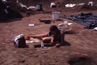 Excavating Feature 239 O Amy and Annie excavated Feature 239 O that was a basin shaped feature near feature 239 N on the eastern side of the house structure. The feature was shallow only going 15 cmbss. The first half of the feature contained charcoal and pottery. The second half of the feature contained unfired clay just like feature 239 N. Feature 239 N and 239 O are very close to each other and have similar artifacts in each one. This area of the house could possibly be where the clay pots were being constructed based on the unfired clay found at those two features. Some grit-tempered pottery, which is a Woodland component, was also recovered. This indicates dual occupancy of the site by two different groups of people at two different times in history.
Feature 239 S
 Excavating a feature
 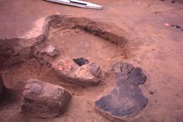 Excavating a feature
Two college crew member for MVAC discovered and excavated a feature just on the southwestern boundary of the house. This feature was named Feature 239 S and was excavated by Mandy and Danielle. This feature was identified because of the pottery cluster that protruded from the ground surface. Within 5-10 cmbss the remains of one whole side of a pot was uncovered. Two Valley View Rims (1500-1625 A.D.), FCR, and flakes were found in this artifact cluster. This small artifact cluster feature had a maximum depth of 25cmbss. The pottery vessel half that was in the ground was very badly damaged possibly due to the bulldozer that scraped the topsoil off to expose the features beneath. During the fall and winter the lab staff will reconstruct the pot. Again, there were two post molds within the feature, and these were labeled post molds A and B of Feature 239 S. These post molds, unlike the others, were not excavated due to time constraints.
Feature 260
 Mapping a feature Feature 260 was excavated by Beth and Lauren. This feature was given a number other than 239 because it was located in the northeast corner of the site just outside of the house. At first this feature was thought to be a Woodland site, which is older than the Oneota house. This feature was surrounded by dark stain that may have been a possible midden accumulation. A midden is an area where debris has accumulated on the surface, rather than having been disposed of in a pit. This feature was also separated into Area A and Area B just like feature 239 M. Area A of this feature was a dark charcoal area. Area B is a lighter more mottled surrounding soil. The two areas were excavated separately. Only a few artifacts were recovered from the feature.
A few pieces of shell tempered pottery were found, which indicates that this is in fact not a Woodland feature because Woodland people used sand or grit to temper their pottery. A few pieces of grit-tempered pottery were recovered as well, indicating dual occupancy of this area of the site, with the later occupants incorporating some of the artifacts from the earlier occupation.
Feature 261
Feature 261 was located just outside of the house structure in the southeastern corner near feature 239 M. This feature went down about 55 cmbss. Mandy and Danielle who were part of MVAC’s college crew excavated the feature. Unlike the Public Field School, this feature was excavated in 20 cm levels to save time, as opposed to the more careful 5 cm levels the public field school was using. Feature 261 was an oval shaped pit that contained a large amount of pottery on the eastern side and numerous flakes in the center and western portion of the feature. Most of the pottery was heavily burned and contained a high degree of polishing. A Madison Triangular point tip, some shell, and animal bone pieces that were in poor condition were recovered. There was some burning going on at this pit and it could possibly have been used for disposal of refuse after burning was done.
Post Mold 205
 Excavating a feature
Gene had the opportunity to excavate post mold 205 that was a large center post for the house. The reason this may have been a center post is because the post stain shows it to be a large post mold compared to the post stains outlining the house. This post mold was located just east of feature 239 K and was aligned with the post mold found within feature 239 K. Post mold 205 went down 40 cmbss and was very well defined. One piece of FCR and 1 pot sherd were recovered. These items may have been thrown into the posthole for supporting the wooden beam up.
Wrap-up
Thanks to the help of these hard working public field school participants MVAC was able to obtain a better understanding of Oneota houses and their usage. The labor provided by the Public Field School enabled us to excavate many more features and to do it more slowly and carefully than would otherwise have been feasible for just the college crew. Their efforts have made a major contribution to our understanding of the archaeology of the area. Thanks!
2000 Excavations
by: Connie Arzigian, Senior Research Archaeologist, MVAC; Lecturer, UWL Department of Archaeology & Anthropology
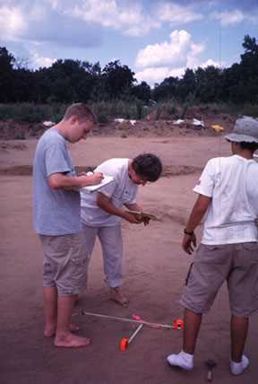
Starting in the middle of June 2000 the University of Wisconsin-La Crosse Archaeology Field School was very active at the Krause site. On a low terrace in Onalaska twenty two college students in the Archaeological Studies Program learned to be archaeologists by excavating a prehistoric Native American village. Directed by James Theler and Robert Boszhardt, the students spent six weeks at this site. After the completion of the UWL Field School Connie Arzigian directed a variety of interested individuals including Middle School and High School students along with members of the public in further excavations of the site.
 Pottery
 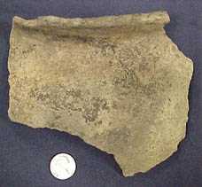 Pottery
 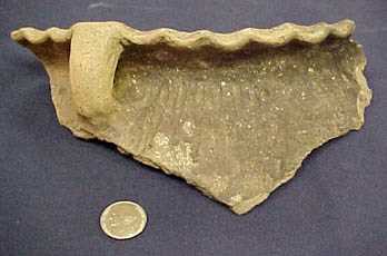 Pottery
Based on the kinds of ceramics recovered, the site dates to around 1500 AD. Several hundred “features” or dark stains in the ground that represent places where the Native Americans dug storage pits to store their corn, beans, and squash were identified. These pits are usually about 2-4 feet wide, and sometimes more than 3 feet deep. Once they had been used as storage pits for a few seasons, they were often too dirty to reuse for storage, and the local village garbage was dumped into them. For archaeologists, this garbage provides our best clues to daily life in the past. We found hearths lined with burnt limestone and filled with ashes. There were fragments of pottery and digging tools thrown in them, along with lots of charcoal and animal bones such as fish heads that were tossed into the fire, and have been preserved.
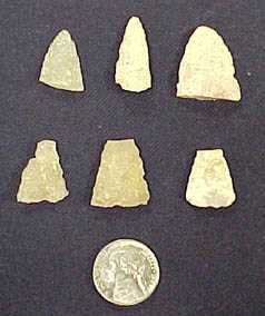 Triangular arrow points
 End scrapers
 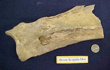 Bison shoulder blade hoe
 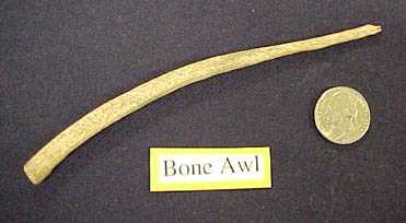 Bone awl
The archaeologists found pottery that had been tempered with shell, and decorated with various kinds of lines and dots decorating the rims. There were end scrapers used to scrape deer hides, an awl, grinding stones, and triangular arrow points. The people used the shoulder blades from buffalo to make digging tools or hoes. We found a number of these tools all worn down and discarded in pits or in the fireplaces.
The archaeologists used everything from a bulldozer to remove the plow zone, shovels to gently skim thin layers of soil from the pits, or trowels, bamboo picks and paint brushes to expose and map all the artifacts. Each pit is excavated in halves, with one half dug first, to provide a cross-section through the pit. This “profile” will help to identify the different kinds of activities involved. Every 10 cm level of every pit feature was mapped, and the profile was carefully mapped and photographed, with the soils and artifacts described. In one place the people appear to have cleaned out a hearth and dumped the ashes in a pit. The garbage in another pit looked like the remains of a fish boil.
 Excavating a feature
Most of the soil was screened through 1/4 inch screens to recover the artifacts. But in addition to the more obvious artifacts, the archaeologist took “flotation” samples (bags of dirt from the features) to recover the very small things that are at the site, including the charred wood, corncobs, other seeds, and all of the small fish bones, crawfish remains, and other things that people ate, as well as the tiny flakes from their stone tool manufacture. Well over a ton of soil was brought back to the Archaeology Lab at the University.
at the University of Wisconsin-La Crosse
Contact us
- 1725 State Street
La Crosse, Wisconsin 54601 USA - Call 608.785.8463
- Email us