Site Snippets
Pammel Creek – Profile Map
 Profile and map
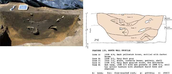
Careful excavation and mapping of features, knowing what was found with what, and where it was found, helps archaeologists to know what people were doing in the past. This provides the context of the artifacts.
A site is like a layer cake, and the different layers represent different activities. Archaeologists must understand the vertical placement of artifacts in order to know what happened over time. Drawing profile maps, the cross-section of a feature or unit, allows these vertical zones to be recorded and interpreted.
Pictured is feature 139 from the Pammel Creek site (located south of La Crosse, Wisconsin) after half of the feature had been excavated, exposing the profile (left). The drawing shows the different zones defined in the pit. Each zone may represent a separate activity such as a separate dump of debris into the pit (right).
at the University of Wisconsin-La Crosse
Contact us
- 1725 State Street
La Crosse, Wisconsin 54601 USA - Call 608.785.8463
- Email us