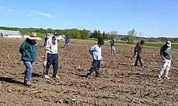
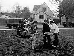
Surface Survey
Surface or "pedestrian" survey is the most common way to find sites in plowed fields. Artifacts are exposed by plowing, and are visible on the surface. Crews, often made up of volunteers, line up and sweep across fields looking for artifacts. Surface survey works best where there is little vegetation covering the ground, such as in the spring.
Many sites are also found this way by farmers who find artifacts on their fields. When they keep track of where things were found, and tell an archaeologist about the finds, they're making an important contribution to archaeology.
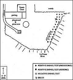
Shovel Testing
In grassy or wooded areas, sites can be found by digging small holes (roughly 50 cm diameter) at regular intervals (usually 10-15 meters apart). The soil is screened to look for artifacts. Each hole is mapped, and any artifacts are mapped by hole and bagged separately. Because this digging destroys a portion of the site, it should be supervised by trained archaeologists who have a good reason for investigating an area.
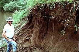
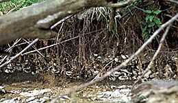
Examining Creek Banks
Sites may also be found by examining eroding stream banks. These sites have often been buried by flood deposits that have preserved the archaeological material. Many times these sites form a layer cake representing a series of occupations in the same area. The site's stratigraphy can then be recorded from the eroded bank.
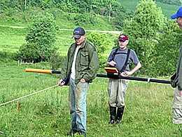
Indirect Methods
New technologies are making available a wide range of remote sensing techniques. Archaeologists have found sites through examination of air photos, various kinds of radar, including ground penetrating radar, and other indirect methods. Remote sensing techniques work best on sites that have features such as walls or deep pits that are distinctly different from the surrounding soil. Radar or pulses of electricity are systematically sent into the ground. Distinct features will provide a different reading from that of the surrounding soil. These techniques have not had as much application in the Midwest as in other parts of the world such as the southwestern United States or the Middle East, where archaeological features such as buried walls provide more readily identifiable patterns.