
Posted 2:56 p.m. Friday, March 29, 2024
Annual student mapping event provides research experience, internship opportunities
Have you ever tried to make your own map? It’s harder than it may seem.
UW-La Crosse students focusing on Geographic Information Systems (GIS) and mapping participate in the annual GIS and Mapping Poster event, showcasing their research for faculty within the Department of Geography & Environmental Science and local agencies. The event, launched in 2014, is marking its 10th year.
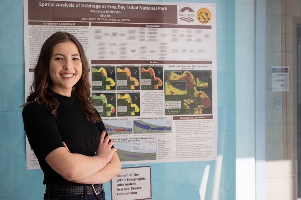
Madeline Meltesen, a senior majoring in archaeological studies with minors in history, earth science and geoarchaeology and a certificate in GIS, was among those who participated in the December 2023 GIS and Mapping Poster event. Her projects were awarded first place in the GIS category and second place in the mapping category.
“The event was a very valuable experience for me as a student because it was my first opportunity to present my research in a poster presentation style,” Meltesen says. “I got to describe my posters to faculty and other members of the community who are not archaeologists. Presenting at the event helped me to pinpoint which parts of my research require more explaining to a non-archaeologist, and what words I need to make sure I define to eliminate jargon and ensure everyone can understand the posters.”
Professors Joan Bunbury and Gargi Chaudhuri, who coordinate the event, explain that it’s open to all students enrolled in geography courses with a spatial analysis or mapping component, as well as students taking part in undergraduate research related to spatial analysis.
“The different projects show application of the geocomputational skills or quantitative skills that the students have learned in their course,” Bunbury and Chaudhuri say. “Learning a skill and applying it with your own dataset is challenging. It involves a lot of critical thinking, problem solving, data analysis and presentation. All these are good non-academic skills that are important in the job market.”
The fact that most students present work from a course rather than undergraduate research makes the event more accessible.
“When the opportunity to develop or hone these skills is wrapped within the scope of a course, it benefits more students versus undergraduate research, where typically one to two students per semester are doing geocomputational projects,” Bunbury and Chaudhuri say.
Meltesen says the event was great practice before she presents her research at two upcoming events, Research in the Rotunda in March and the National Conference on Undergraduate Research (NCUR) in April.

“In the fall, I will be starting at the University of York in the United Kingdom to pursue my master's in digital archaeology. This experience has certainly given me a good foundation to build upon when it comes to using GIS methods in archaeology,” Meltesen says. “I am very glad that the event allowed for so much creativity regarding the subject of the posters, giving me the freedom to incorporate my archaeological interests despite it being a Geography & Environmental Science Department event.”
Local agencies attend the GIS and Mapping Poster event to help judge the presentations. Agencies typically in attendance include the Upper Midwest Environmental Science Center (UMESC), the City of Onalaska’s Planning Department, the City/County of La Crosse and Dairyland Power Cooperative. There’s a history of student participants securing internships with the local agencies through connections made at the event.
“We try to bring in GIS and mapping professionals from the community, so the event is mutually beneficial for both students and the local employers,” Bunbury and Chaudhuri say. “The potential employers get to see the skills students have gained (quantitative, mapping, presentation, and communication [both oral and written]) and interact with them, which can lead to internship or employment opportunities. For example, UMESC, the City/County of La Crosse and Dairyland Power are some employers that have hired our students as interns consistently for the past few years and/or provided them with full-time employment upon graduation.”
Up to 40 student posters are featured every year. Student presenters can elect to have their projects judged by faculty and local agencies. Top-ranked students receive awards.